
A dry window is opening up across the Indiana and the Eastern Corn Belt, which should provide a great opportunity for harvest over the next 10 days to two weeks.
In the Beacon Credit Union Harvest Weather Forecast, high pressure settles in over the Great Lakes as we finish the weekend. That dome of Canadian high pressure will bring slightly cooler air to start the week, rotating down into Michigan to finish the weekend. The coldest temperatures will likely occur early Monday morning. We could see some 40s and upper 30s across parts of Indiana, and solid 30s across a large part of Michigan. As a matter of fact, freezes are possible in northern Michigan.
The cold air moving into Michigan may wring out a few Sunday afternoon spits, sprinkles, or light showers in the northern half of the state. However, later this week, temperatures will climb. Sunshine will dominate all of Indiana and most of Michigan, bringing excellent evaporation and fantastic drying opportunities. That pattern extends through the weekend and even into early next week.
All that being said, a minor frontal boundary will try to work its way through the Great Lakes region late Thursday and Friday of this week. That means we are watching for clouds and even a few showers in Northern Michigan and the Upper Peninsula, but we do not feel it will have a big effect on southern Lower Michigan.

Looking ahead to the week of the 12th, we start with a dry Monday before clouds increase on Tuesday. From Tuesday midday through afternoon and early Wednesday, another system tracks across the Great Lakes. This system will throw moisture all the way down through the northern half of Indiana. It will not bring a lot of moisture—we are talking about roughly a tenth to maybe half an inch, with coverage at 75% in Michigan but only 50% in Indiana north of I-70, and nothing farther south.
Dry weather returns for Wednesday afternoon and evening. Clouds increase on Thursday the 15th as a strong upper-level low comes out of the upper Midwest and northern Plains right into the Great Lakes for the 15th and 16th. This front has a moisture potential of 0.10″ to 0.25″ with coverage around 90% across Michigan and Indiana combined.
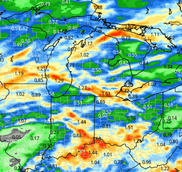
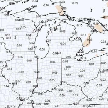
The bigger story is likely what comes behind it: a significant push of cool air backs in across Michigan and the Great Lakes, impacting the early part of the week of the 19th. We may have to increase talk of frost farther south if this cold air incursion holds. All of this means a much drier outlook going forward than what we experienced this past week. The map below shows 10-day rain potential through the 16th, with the majority of what is shown arriving from the 13th through the 15th.
Extended Period
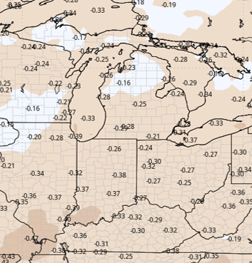
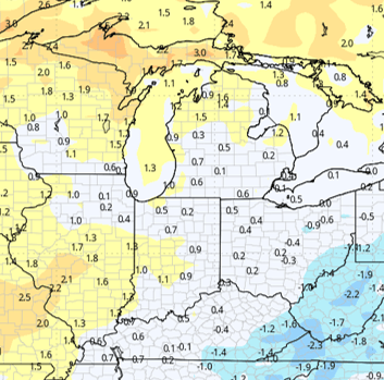
Conditions remain mostly dry in the extended period through Day 16. We see another round of cool air coming out of the Canadian prairies sagging southward into the Great Plains toward the middle of that week, which may back temperatures up a bit more over a small stretch. However, for the overall nearby and extended forecast windows combined, temperatures will still be above normal. The rest of the extended forecast window does not bring much excitement; it stays mostly dry as temperatures rebound.
Weeks 3 & 4
Week 3 Precipitation:
Week 3 Temperature:
Week 4 Precipitation:
Week 4 Temperature: