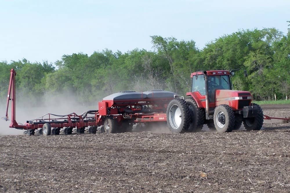

A dry weekend is settling in over the Great Lakes region. We are going to be seeing sunshine for most of the weekend over all of Indiana and Michigan. Temperatures are settling into being a little bit below where we spent most of last week, but still quite mild for this time of year. Remember, it is only April! Evaporation rates for both Saturday and Sunday will be at near maximum, That means we should see a quarter to third of an inch of moisture moving out of our soil profile into the atmosphere both days. Dry down. We should be nice for the entire weekend.
A strong upper level low combines with a surface low coming out of the New Mexico Four Corners region on Sunday night to track across the eastern corn belt for Monday. This strong low will bring us significant precipitation potential over all of Great Lakes/Ohio Valley region Monday afternoon into early Tuesday. We look for most of this moisture to be shower based, but we won’t rule out some thunderstorms.

The best chance of thunderstorms will be in central and southern Indiana (although central MI cant get a pass just yet). Timing of the moisture will be predominantly Monday evening through the overnight and into the pre dawn hours of Tuesday morning. With that timing, we suggest that the best threat of severe weather is going to stay well west into parts of Illinois and those happen Monday afternoon/evening. Here, rain totals are likely going to come in in that .25”-1”range. However, we think that most of the area will be half to ¾”. A nice gentle rain for most of us.
Here’s where it gets a little more exciting, when we’re talking about planting, at least for areas in the north. We are looking at a drier pattern unfolding from Tuesday of this coming week right on through at least Sunday (3rd). And perhaps we can give you a dry Monday of next week as well.
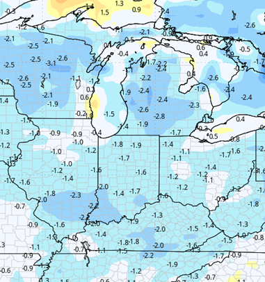
The dryness comes in initially with temperatures holding as mild for Tuesday afternoon and Wednesday. But by Thursday colder air arrives, coming in from the north. This means slightly below normal temperatures for Thursday, Friday and to start the weekend. The dryness will be supported by sunshine, and good evaporation rates. We should see at least a quarter inch of moisture per day trying to move out, although we do have some concern on those cooler days that we are slightly under that evaporation level. Still, that stretch of days with no precipitation will be one of the longest stretches that we’ve seen in a minute, at least for northern IN and most of MI. Southern Indiana may have to deal with some longer lingering showers Wednesday morning, and then another surge from the south Friday, but regional coverage is minor.
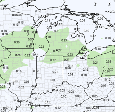
Speaking of minor, a weak front will try and sag through overnight next Monday night the 4th into early Tuesday the 5th. Moisture availability not over the top, but I think we have to allow for a few hundreds to a few tenths, mostly in the northern third of Indiana and the southern half of Michigan. Behind that little sagging front, we do see a pattern shift, particularly to our north. A very active precipitation track lays in coming all the way from the Northern Rockies, across the Northern Plains, the Upper Midwest and right into the Great Lakes region. That will fuel scattered on again off again rounds of showers for likely next Tuesday afternoon, evening right on through Wednesday, Thursday, Friday, even into the 8th and 9th. So that’s going to be the following weekend. What we’re looking at here is more rain to the north, so Michigan could pick up multiple rounds of moisture. With grand totals of .5”-1.5”. Farther south though Indiana may see some hit and miss action in there, but probably misses out on major moisture.
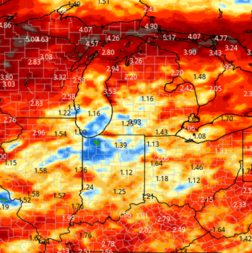
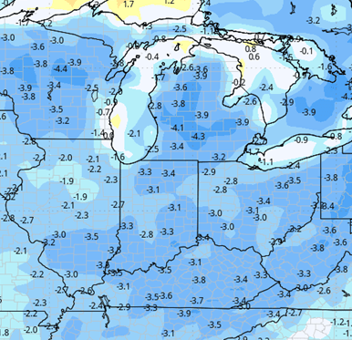
In Indiana, we’re looking at a system for late the 7th into early the 8th and that could be the only round. But what we’re also expecting. Is another surge of cool temperatures for the 9th and 10th, and those cool temperatures are something that may stick around into the following week. This is not something that is going to be causing a problem with soil temperatures, but if you’re listening to this forecast with a gardening mindset, there’s still are a few rounds of chill trying to head towards us. The map presented below shows 2-week combined moisture projections for the region.
Extended Period:
The extended forecast period going through the 15th features more of the same. Another front brings rain chances up to half an inch. We see temps moderate a bit after the 11th, getting back closer to normal.
Weeks 3 & 4:
Above normal precipitation should be expected for week 3 and near normal precipitation for week four as we move toward Memorial Day. Temps will be on the cool side both weeks, which will not help with drying as much as we would like.
Week 3 Precipitation:
Week 3 Temperature:
Week 4 Precipitation:
Week 4 Temperature: